
Traffic
Avimor Development Traffic Impact
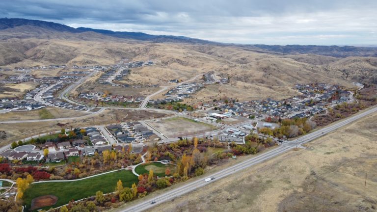
With 800+ Avimor homes built and its commercial development in Ada County well underway, users of State Highway 55 and its 8 intersections north from State Highway 44 (State Street) are well aware of increased traffic volume and longer wait times as well as the addition of several traffic signals and turning lanes.
A 2020 analysis of the impact of the Avimor Boise County Development on State Highway 55 corridor identified SH 55 / SH44 (State Street) as a high-volume intersection that was already exceeding Idaho Department of Transportation (ITD) standards for capacity on weekday and Friday p.m. Peak Hours.
The same analysis estimated that by 2025, with 360 single- and 240 multi-family housing units, the Avimor Boise County Development will generate 5,152 daily net new trips on SH 55. By 2030, with 1,600 housing units and 70,000 square feet of commercial space, the estimate is 14,801 daily net new trips. In addition to some traffic mitigation proposed by Avimor, ITD has identified additional improvements it will require of the developer at specific phases of its buildout.
While we believe ITD will enforce its requirements and assign Avimor its appropriate responsibilities to mitigate traffic levels, we believe the resolutions will be high-cost, long and disruptive. Examples include the SH 55 / SH 44 intersection (it is already fully built out so ITD needs to determine its future configuration and/or alternatives) and the SH 55 corridor (a study is recommended to identify both the need and desire for additional lanes in both directions north of SH 44). Traffic congestion in the area will be a problem for the foreseeable future.
Traffic Impact Studies
Fortunately, there is data and analysis to document recent increases and to form reasonable estimates of future traffic volume as Avimor completes its Ada County buildout and moves into Boise County. Avimor partners contracted with Kittelson & Associates to conduct a Transportation Impact Study (TIS) for its Boise County Development.
The Avimor Boise County Development is located in southwestern Boise County just north of the current Avimor Village 1 Development in Ada County. Access for the Development will be from the two existing public street accesses from State Highway 55, Avimor Drive and McLeod Way, as well as two in Boise County: one new access and the use of Pearl Road. The Idaho Transportation Department (ITD, a state agency) will be the primary approval agency in addressing the traffic growth. The Ada County Highway District (ACHD, a countywide independent taxing district) is a commenting agency in recognition that the Development will send traffic into Ada County for employment and services.
The Study analyzed existing 2020 conditions, general regional growth, and the Development’s direct impacts on SH 55 and several connecting roads by 2025, 2030, and 2032 (the scheduled buildout of Avimor’s 3 phases in Boise County). It evaluated 10 intersections, three Avimor access intersections, and 12 roadway segments. (pp. 32-33). It focused on traffic volume during the Weekday a.m. and Weekday p.m. Peak Hours of a typical weekday, as well as the Friday p.m. Peak Hours during the summer months. The Study followed the operating standards of ITD and ACHD and used the methodologies stated in Section 7106.6 of the ACHD Policy Manual. (p. 34)
Performance standards for intersections and roadway segments included:
- Level of Service (LOS), a ranking based on the average delay experienced by drivers. LOS grades range from A (free-flowing traffic, very low delay times) to F (stop and go, high delay times considered unacceptable to most drivers). ITD’s threshold is LOS D or better for all intersections.
- Volume (number of vehicles) compared to capacity of the road, or V/C. A V/C ratio of 1.0 indicates an intersection is operating at capacity; a ratio higher than 1.0 exceeds the road’s capacity. ITD’s threshold is a V/C ratio of 0.90 or lower for the overall intersections as well as for each lane group. (p. 35)
The report, dated September 2020, documents the findings of the Study and the recommendations for mitigation of deficiencies. The findings show that with each Development phase, the number of intersections and road segments expected to exceed ITD’s acceptable standards increases, as does the number of Peak Hour periods that standards are exceeded. Avimor developers have made some improvements to address increased traffic and plan others, but the Study identified many more that will need to be made to maintain ITD’s standard.
2020 Key Findings
2025 Key Findings
2030 Key Findings
2032 Key Findings
2020 Key Findings
At the time of the Study, all intersections and road segments were operating at acceptable standards (LOS D or better, V/C of 0.90 or lower) during Weekday a.m. and p.m. Peak Hours except (pp. 5-6):
SH 55 / Brookside Lane, during Weekday p.m. and Friday p.m. Peak Hours (LOS F prior to installation of traffic signal)
SH 55 / Dry Creek Road, during Weekday p.m. and Friday p.m. Peak Hours (LOS F)
- SH 55 / Dry Creek Road, during Weekday p.m. and Friday p.m. Peak Hours (LOS F)
- SH 55 / SH 44 (State Street), during Weekday p.m. and Friday p.m. Peak Hours (LOS F)
- SH 55 segments between Beacon Light Road and McLeod Way, during the Friday p.m. Peak Hours (exceeded LOS E)
2025 Key Findings
In addition to considering general regional growth, the 2025 analysis assumes traffic volumes from full development of Avimor Village 1 and 40% buildout of Dry Creek Ranch Development (p. 6), both in Ada County, as well as full buildout of Avimor Boise County Area 1. The proposed Area 1 development, with 360 single-family dwelling units and 240 multifamily dwelling units, is estimated to generate a total of 5,152 daily net new trips by 2025. (p. 8)
The following intersections and road segments are all expected to exceed acceptable standards (LOS D or better, 0.90 V/C or lower) during Friday p.m. Peak Hours, and additional Peak Hours as listed (pp. 8-10):
- SH 55 / Avimor Drive
- SH 55 / Brookside Lane, and Weekday p.m.
- SH 55 / Dry Creek Road, and Weekday a.m. and p.m.
- SH 55 / Floating Feather Road, and Weekday p.m.
- SH 55 / Hill Road
- SH 55 / SH 44, and Weekday a.m. and p.m.
- SH 55 segments from Beacon Light Road to McLeod Way
2025 traffic condition mitigations:
Recommendations fall into two categories: improvements by others (ITD, ACHD, Other Developments) and those triggered by the Avimor Development. They range from maintaining landscaping around intersections to widening segments of SH 55 to four lanes and constructing an underpass under SH 55. (p. 25-26) Beginning with the 2020 existing conditions and through 2032, the report states that the high-volume SH 55 / SH 44 intersection is fully built out so ITD will need to determine its future configuration and evaluate potential alternate treatments. (pp. 5, 10, 15, 23)
The Study found no ACHD Capital Improvement Plan (CIP), Integrated Five Year Work Plan (FYWP), or ITD Statewide Transportation Investment Program (STIP) projects within the study area planned to be completed by 2025. (p. 6)
2030 Key Findings
In addition to considering general regional growth and in-process development trips described in 2025 conditions, the 2030 analysis assumes 80% buildout of the Dry Creek Ranch Development (p. 10) and full buildout of Avimor Boise County Area 2. The proposed Area 1 and Area 2 Development (1,600 housing units and 70,000 square feet of commercial space combined) is estimated to generate a total of 14,801 daily net new trips by 2030. (p. 12)
The following intersections (and/or specific approaching lanes) and road segments are all expected to exceed acceptable standards (LOS D or better, 0.90 V/C or lower) during Friday p.m. Peak Hours, and additional Peak Hours as listed (pp. 13-16):
- SH 55 / Avimor Drive, and Weekday a.m. and p.m.
- SH 55 / Brookside Lane, and Weekday a.m. and p.m.
- SH 55 / Dry Creek Road, and Weekday a.m. and p.m.
- SH 55 / Beacon Light Road, and Weekday p.m.
- SH 55 / Floating Feather Road, and Weekday a.m. and p.m.
- SH 55 / Hill Road, and Weekday p.m.
- SH 55 / SH 44, and Weekday a.m. and p.m.
- Cartwright Road / Bogus Basin Road, and Weekday p.m.
- Harrison Boulevard / Bogus Basin Road / Hill Road, and Weekday a.m. and p.m.
- SH 55 segments from Beacon Light Road to McLeod Way, and Weekday a.m.
- SH 55 segments from SH 44 to McLeod Way, Weekday p.m. (pp. 13-16)
In reference to the SH 55 intersections at Floating Feather Road and Hill Road, the report states that “ITD will need to determine the future vision for the SH 55 corridor and the timing and feasibility of the appropriate treatments.”
2030 traffic conditions mitigation:
Recommendations include adding turning lanes at a number of SH 55 intersections and at Harrison Boulevard / Bogus Basin / Hill Road, adjusting traffic signal timing, widening additional SH 55 segments to 4 and 6 lanes, and constructing a new Avimor Boise County access with turning lanes. (pp. 26-27). Two overarching recommendations are to determine the best course of action for improving the SH 55 / SH 44 intersection and to complete a SH 55 corridor study to identify the need and desire for additional widening of SH 55 beyond two travel lanes in each direction north of SH 44.
The Study found no ACHD Capital Improvement Plan (CIP) or ITD Statewide Transportation Investment Program (STIP) projects within the study area planned to be completed by 2030. (p. 10)
2032 Key Findings
In addition to considering general regional growth and the buildout of development outlined in the year 2025 and year 2030 analysis, the 2032 analysis assumes full buildout of the Dry Creek Ranch Development (p. 16) and Avimor Boise County Area 3. The proposed Avimor Boise County Area 1 + Area 2 + Area 3 Development (totaling 1,900 housing units, 107,600 square feet of commercial space, and 62,000 square feet of self-storage space) is estimated to generate a total of 18,270 daily net new trips. (p. 20)
The following intersections (and/or specific approaching lanes) and road segments are all expected to exceed acceptable standards (LOS D or better, 0.90 V/C or lower) during all three Peak Hour periods (pp. 21-23):
- SH 55 / Avimor Drive
- SH 55 / Brookside Lane
- SH 55 / Dry Creek Road
- SH 55 / Beacon Light Road
- SH 55 / Floating Feather Road
- SH 55 / Hill Road
- SH 55 / SH 44
- All SH 55 segments
The following are expected to exceed acceptable standards during some Peak Hours (pp. 23-24):
- Cartwright Road / Bogus Basin Road, Weekday a.m. and p.m.
- Harrison Road / Bogus Basin Road / Hill Road, Weekday a.m. and p.m.
- SH 55 / McLeod Way, Friday p.m.
- Brookside Lane east of SH 55, Weekday p.m.
2032 traffic conditions mitigation:
Recommendations include further widening of SH 55, improvements at Harrison Boulevard / Bogus Basin Road / Hill Road intersection, and constructing the SH 55 / Pearl Road Avimor Boise County access with turning lanes. (p. 27) In addition, ITD will need to determine the future vision for the SH 55 corridor and the timing and feasibility of the appropriate treatments. (pp. 106, 126, 127)
The Study found no ITD Statewide Transportation Investment Program (STIP) projects within the study area planned to be completed by 2030. ACHD’s Capital Improvement Plan includes Beacon Light Road improvements (Eagle Road to SH 55) between 2031 and 2035. The Dry Creek Ranch Transportation Impact Study was conditioned to implement a number of mitigation projects by 2031 that include widening SH 55, adding turning lanes at several intersections, and upgrading Brookside Lane and Dry Creek Road to ACHD standards. (pp. 16-17)
ITD Comments to Boise County
In April 2021, ITD shared with the Avimor Partners its intended response to Boise County Development Services regarding its review of the Avimor Boise County Development TIS. (April 8, 2021 letter re: ITD Development Condition Memo) The letter states that Avimor Boise County is already generating significant site traffic. It also points out that the current signal at the SH 55 / Avimor Drive intersection was permitted as a temporary improvement; the TIS identified that intersection as exceeding standards (0.90 V/C) by 2025 during Friday p.m. Peak Hours, and ITD cannot have a temporary signal operating with poor performance.
ITD will require Avimor to do the following:
- Mitigate SH 55 / Avimor Drive signal for Friday p.m. Peak Hours during summer months so that the northbound through traffic V/C does not exceed 1.0. Within 1 year of the V/C exceeding 0.9, Avimor must widen SH 55 to a 4-lane section at least 1500 feet north and south of the signal.
- Additional mitigation around Avimor Drive will be negotiated prior to the final plat of anything beyond 600 residential units in Boise County Areas 2 and 3 (to be served by the proposed new access point and by Pearl Road).
- Limit McCleod Way to right-in right-out and construct an underpass when monitoring determines left movements fail.
- Construct north- and southbound right and left turn lanes when the new Avimor access point is built in Boise County.
- Construct a northbound left turn lane at the SH 55 / Pearl Road intersection prior to any building occupancy in Area 3.